Colbert County Commission
Subdivision Regulations of Colbert County
Amended August 2, 2022
About this version: This is an accessible text version of the document. Some formatting may differ from the original PDF. To view the document in its original layout, select View Original PDF.
Article I - General Provisions
Section 1:01 Authority
Under the authority of the Code of Alabama, Title 11, and as amended by Act 97-422, Acts of the Legislature, State of Alabama, 1997 which act is hereby made a part of these regulations, the Colbert County Commission at its meeting of February 3, 1998 adopted the following revised regulations.
Section 1:02 Jurisdiction
From and after the date of February 3, 1998, these regulations shall govern each and every subdivision of land in all areas of the county as now or hereafter established outside the boundaries of municipal corporations; provided however, that where a municipality now or in the future is authorized to exercise and in fact does exercise subdivision control outside its municipal boundaries, such areas shall be required to meet the stricter of the regulations as set forth by the governing bodies.
Section 1:03 Separability and Severability
The provisions of this Act are severable. Should any article, section, subsection or provision of these regulations be declared by a court of competent jurisdiction to be invalid or unconstitutional, such decision shall not effect the validity or unconstitutionality of these regulations as a whole or any part thereof other than the part so declared to be invalid or unconstitutional.
Section 1:04 Amendments
The Colbert County Commission may from time to time adopt amendments to these regulations in an effort to increase the effectiveness of said regulations or expedite the approval of subdivision plats.
Section 1:05 Definitions
- ADT (Average Daily Traffic):
- Total volume of vehicles during a given 24 hr. period, as measured during a non-holiday weekday.
- Alley:
- Any public right-of-way designed primarily for vehicular access to the back of premises otherwise abutting on a street.
- Application Assembly:
- The packet of materials that the developer is required to submit with his or her application for proposed plat approval.
- Curb or Curb Line:
- The inside vertical face of a masonry curb, the centerline of a valley gutter, or the edge of pavement where no curb or gutter exist.
- Cul-de-sac:
- A special turning area at the end of a dead end street.
- Dedication:
- The deliberate assignation of land by its owners for any general or public uses, reserving to himself no other rights than such are compatible with the full exercise and enjoyment of the public uses to which the property has been devoted.
- Developer:
- Any individual, firm, association, syndicate, co-partnership, corporation, trust or any other legal entity commencing proceedings under these regulations to effect a subdivision of land hereunder for himself or for another.
- Family Subdivision:
- A subdivision of land among immediate family members.
- Final Plat:
- The completed subdivision plat in form for approval and recording.
- Flood, One Hundred (100) Year:
- A flood that has, on average, a one (1) percent chance of being equaled or exceeded in any given year.
- Flood, Ten (10) Year:
- A flood that has, on average, been equaled of exceeded at a frequency of once every ten (10) years.
- Flood, Twenty-Five (25) Year:
- A flood that has, on average, been equaled of exceeded at a frequency of once every Twenty-Five (25) years.
- Hardship:
- An unusual situation on the part of an individual property owner, which will not permit the full utilization of property. A hardship exists only when it is not self-created.
- Immediate Family Member:
- As defined in Blacks Law Dictionary, a person’s parents, spouse, children, and siblings.
- Improvements bond:
- a contract between the developer, Colbert County and the surety guarnteeing the construction of the subdivision as shown in the submittal.
- Licensed Engineer:
- An engineer properly licensed and registered in the State of Alabama in good standing with the Alabama State Board of Licensure for Professional Engineers and Land Surveyors
- Licensed Land Surveyor:
- A land surveyor properly licensed and registered in the State of Alabama in good standing with the Alabama State Board of Licensure for Professional Engineers and Land Surveyors.
- License Inspector:
- The person or persons appointed by the County Commission to enforce the county’s subdivision regulations pursuant to Code of Alabama 1975, § 11-24-3, utilizing the authority granted to a license inspector under Code of Alabama 1975, §40-12-10.
- Maintenance bond:
- a contract between the developer, Colbert County and the surety guaranteeing the quality of work in the completed subdivision.
- PRE-SALE AGREEMENT:
- An agreement between a developer and a prospective purchaser evidencing interest in purchasing a lot within a subdivision development in the event the proposed subdivision plan is approved by the county pursuant to Code of Alabama 1975, § 11-24-1 et seq. and these regulations. A pre-sale agreement is not a contract to purchase and shall clearly state that no final sale of the property shall take place until and unless the developer fulfills the requirements set out in Code of Alabama 1975, § 11-24-2.
- Probate Judge:
- The Judge of Probate of Colbert County, Alabama
- Permit to Develop:
- An instrument issued by the County Engineer following approval of a proposed plat by the County Commission and which authorizes the developer to proceed with the development of the subdivision.
- Planned Development –
- A subdivision of land consisting of one or more buildings, sites, or units which is not subdivided into customary lots, blocks, or streets and thus is contained on one common parcel. This type of development shall not only be on a common parcel but shall also have a common owner who shall be responsible for all infrastructure and drainage within the development. A building footprint shall be the maximum boundary allowed to be transferred, sold, or leased in this type of development.
- Proposed Plat:
- A tentative plat of the proposed subdivision to be submitted to the County Engineer for consideration, and approval of the County Commission.
- Roadbed:
- The graded portion of a road or street within the top and side slopes prepared as a foundation for the pavement structure and shoulders. The surface of the roadbed is the subgrade.
- Roadway:
- That portion of a street between the regularly established curb lines, or that part of a street devoted to vehicular traffic.
- Surety:
- A company who agrees to be responsible for the debt or obligation of another when there is some public or private interest which requires protection from the consequences of the principal's default or delinquency. Said Surety shall be a surety company licensed to do business in the State of Alabama.
- Sidewalk Area:
- That portion of a street not included in the roadway devoted in whole or in part to pedestrian traffic.
- Sketch Plan:
- Drawing submitted prior to the preparation of the Proposed Plat (or Final Plat in cases of minor subdivisions) to enable the applicant to save time and expense in reaching a general agreement with the County Engineer as to the form of the plat and the objectives of these regulations.
- Subdivider:
- Any person who (1) having an interest in land, causes it directly or indirectly, to be divided into a subdivision or who (2), directly or indirectly sells, leases, or develops, or offers to sell, lease, or develop, or advertises for sale, lease, or development, any interest, lot parcel, site, unit, or plat in a subdivision, or who (3), is employed by or directly or indirectly controlled by, or under direct, or indirect common control with any of the foregoing.
- Subdivision:
- The division of a lot, tract, or parcel of land into two (2) or more lots, plats, sites or other division of land, whether described by metes and bounds or by any other description, for the purpose, whether immediate or future, of sale or of building development. It includes re-subdivision and, when appropriate to the context, relates to the process of subdividing or to the land or territory subdivided.
- Subdivision Jurisdiction:
- All areas outside the corporate limits of any municipality in Colbert County, except areas within the territorial jurisdiction of a municipal planning commission presently organized and functional or which shall become organized and functional within six months of February 3, 1998.
- Subdivision, Major:
- and division of a lot, tract, or parcel of land into two (2) or more lots, plats, sites, or otherwise for the purpose of establishing or creating a subdivision through the sale, lease, or building development of the lot or lots. All subdivisions or Planned Development not classified as a minor subdivision.
- Subdivision, Minor:
- Any subdivision or Planned Development with parcels or lots five (5) acres or less fronting on an existing county road that does not involve any new street (or road) or the extension of public utilities and does not require the creation of any public improvements, and does not, in the opinion of the developer's licensed engineer with the concurrence of the County Engineer, create any additional storm water runoff.
- Variance:
- Permission to depart from the literal requirements of these subdivision regulations by virtue of unique hardship due to special circumstances regarding property to be developed. A waiver of the strictest letter of the regulations upon substantial compliance without sacrificing the spirit and purpose of the regulations.
- Watercourse:
- Any depression serving to give direction to a flow of water, having a bed and defined banks. The definition shall also include other generally or specifically designated area where flooding may occur. The flow of water need not be on a continuous basis, but may be intermittent resulting from surface runoff of precipitation.
Section 1:06 TITLE
The regulations shall hereafter be known, cited and referred to as the Subdivision Regulations of Colbert County, Alabama.
Section 1:07 FEES
Colbert County has established the following schedule of fees, as authorized under Code Alabama-1975 Section 11-24-3, to cover costs associated with the inspection and review of subdivision developments. The total fee is dependent on the type of subdivision (as defined in Section 2:09) and is a guide as to the charges that will be incurred by the developer. The developer is responsible for all charges, including inspection and testing, incurred by the county during the subdivision approval process.
Section 1:08 ENFORCEMENT AND VIOLATION
Pursuant to authority granted under Code of Alabama 1975 § 11-24-3(d), the Colbert County Commission shall enforce the provisions of these regulations by the issuance of citations issued by a county license inspector appointed by the Colbert County Commission to enforce these regulations. Acting under authority granted in Code of Alabama 1975 § 11-24-3(d) and § 40-12-10, the county license inspector may issue a citation for the failure to properly obtain the permit to develop required under Section 2:06 and/or for any other violations of these regulations or of Code of Alabama 1975, § 11-24-1 et seq.
As authorized by Code of Alabama 1975 § 11-24-3(a), the fine for noncompliance of any provisions of these regulations shall be $1000 per lot that has been sold, offered for sale, transferred, or leased. A separate citation shall be issued for each violation.
All fines shall be paid to the office of the judge of probate within thirty (30) days of the issuance of a citation by the county inspector, and all fines shall be doubled upon the failure to remit the fine within thirty (30) days of the issuance of the citation.
In addition to the issuance of citations for violation of these regulations, the County Commission retains the right to seek an injunction against any developer or owner who fails to comply with these regulations as provided in Code of Alabama 1975, § 11-24-3(b), and may bring action against a developer or owner to compel compliance with these regulations in the event that work on the subdivision has been completed in violation of these regulations and the requirements of Code of Alabama 1975, § 11-24-1 et seq.
Article II - Approval of Subdivision Plats
Section 2:01 Approval of Subdivision Plats
This section details the general steps necessary to achieve approval of a subdivision in Colbert County. A flow chart is included in Appendix II further outlining this process. Except as specifically provided in Section 2:01(a), no lots within a proposed subdivision may be offered to the public for sale, transfer, or lease before the proposed plat approval has been granted and a permit to develop has been obtained as set out in Section 3-6.
It shall be a violation of these regulations and Code of Alabama 1975, § 11-24-1 et seq. for the developer to file or have filed any plat, deed, property description, or document of property transfer without full compliance with these regulations and Code of Alabama 1975, § 11-24-2.
SECTION 2:01(a) AUTHORITY FOR PRE-SALE AGREEMENTS
As provided in Code of Alabama 1975, § 11-24-1.1, the county engineer may authorize a developer to secure pre-sale agreements from prospective buyers of property included in a proposed subdivision development prior to obtaining the permit to develop required in Section 3-6 under the following circumstances:
- The developer submits a sketch plan as a preliminary plan for the proposed subdivision development as set out in Section 2:06,
- The county engineer is satisfied that the developer’s preliminary plan is likely to be approved under these regulations, and
- The developer has explained to the satisfaction of the county engineer the reasons for requesting authorization to secure pre-sale agreements.
Any pre-sale agreements entered into between the developer and a prospective buyer pursuant to authorization granted under this section shall clearly state that any final sale of property shall not take place until and unless the developer has fulfilled all the requirements of Code of Alabama 1975, § 11-24-2.
Any developer who obtains authority to pursue pre-sale agreements prior to receiving plat approval and the permit to develop shall notify the county engineer in writing once financing for the subdivision development project has been secured. The developer shall then comply with the process for approval of the proposed subdivision plat and obtaining a permit to develop as required in these regulations and Code of Alabama 1975, § 11-24-1 et seq. No final sale of property that is the subject of a pre-sale agreement authorized under this section shall take place until and unless the developer has complied with all the requirements in Code of Alabama 1975, § 11-24-2.
The authorization to pursue pre-sale agreements shall be revoked by operation of law six months after the date granted by the county engineer unless the developer requests an extension of time. No pre-sale agreements may be entered into following the expiration of the six month period until and unless extended by the county engineer.
Any pre-sale agreements executed without the developer obtaining authorization to pursue such agreements as provided herein shall be a violation of this section and Code of Alabama 1975, § 11-24-1.1. Such violation shall be punishable by fines as set out in Section 1:08 and Code of Alabama 1975, § 11-24-3. Additionally, the county engineer may revoke any authorization granted to the developer to secure pre-sale agreements in the event there is any failure to comply with this section.
Section 2:02 Sketch Plan
Whenever the subdivision of a tract of land is proposed within the jurisdiction of these regulations, the developer, or subdivider, is urged to consult early and informally with the County Engineer. The subdivider may submit sketch plans and data showing existing conditions within the site and in its vicinity along with the proposed layout and development of the subdivision. The purpose of this sketch plan review is to afford the subdivider an opportunity to avail himself of the advice and assistance of the County Engineer in order to facilitate the subsequent preparations and approval of plans.
Section 2:03 Proposed Plat Submission
Following sketch plan review or in the event the subdivider does not submit a sketch plan for review, the subdivider shall submit a complete Application Assembly to the county engineer for review of the proposed plat. The application shall be submitted at least 30 days prior to any consideration for proposed plat approval by the County Commission. The Proposed Plat Application Assembly shall include each of the following:
- A letter stating that the proposed plat is being submitted for review. This letter shall state the developer's intent as to the final ownership of any new roads included on the proposed plat if applicable. (The developer is reminded to refer to Appendix IV for the County Road Acceptance Policy; Acceptance of roads for maintenance)
- Application for Proposed Plat Review; (Appendix II)
- At least eight (8) copies of the proposed plat prepared in accordance with the requirements detailed in Section 3:01 of these regulations;
- Construction Plans for all required improvements prepared in accordance with the requirements detailed in Article IV of these regulations (Major Subdivisions only);
- A letter from the Health Department detailing field review by the Health Department for the general lot layout has been completed;
- Any variances requested accompanied by detailed supporting documentation;
- The names and addresses of each adjoining landowner and utility entitled to notice pursuant to Code of Alabama 1975, §11-24-2(b); and
- Letter stating that all off site drainage has been considered and that no adverse effects from the development of this subdivision are expected.
- The application fee of $100.00
- Engineers Certificate
Failure to submit a complete Proposed Plat Application Assembly Initially shall delay the consideration of such plat for approval by the County Engineer and the County Commission.
Section 2:04 Review by County Engineer
The County Engineer shall use this minimum thirty (30) day period to review the submitted Application Assembly and ensure its compliance with these regulations. In the event the Application Assembly does not meet these regulations, the County Engineer shall notify the developer that it is deficient. No further action will be taken by the County Commission or County Engineer until and unless the developer shall correct the deficiencies and resubmit the corrections to the County Engineer for his approval.
If upon completion of the review the County Engineer determines that the Application Assembly complies with these regulations, he or she shall notify the developer in writing to that effect. The County Engineer shall also send proper notice of his/her recommendation for approval, as required in Code of Alabama 1975, § 11-24-2(b), to each of the adjoining landowners and the affected utilities submitted by the developer.
In the event the proposed subdivision is a major subdivision, the County Engineer shall require the developer to submit a detailed construction estimate covering all proposed infrastructure for approval. Once the County Engineer receives and approves this detailed construction estimate, the developer shall be required to provide an acceptable surety to Colbert County equal to 150% of the estimated cost of installing all improvements, including, but not limited to, grading, paving of the streets, and installation of all required utilities and fees encountered during execution of improvements.
Section 2:05 County Commission Approval of Proposed Plat
Once the County Engineer verifies that the Application Assembly meets the County Regulations and, if applicable, the developer provides the required surety, the Proposed Plat shall be submitted to the County Commission for their approval at the next regularly scheduled County Commission meeting. Pursuant to Code of Alabama 1975, §11-24-2(b), the County Commission shall approve the proposed plat in the event that the County Engineer has determined that the proposed plat meets these regulations.
Section 2:06 Permit to Develop
Following the approval of the Proposed Plat by the County Commission, the County Engineer shall issue a "Permit to Develop" for the Proposed Plat. The Permit to Develop allows the developer to proceed with construction of the development in compliance with these regulations. Additionally, the developer may offer lots in the proposed subdivision for sale, transfer, or lease pursuant to the requirements of Code of Alabama 1975 § 11-24-2(c) and 11-24-1-1.
Section 2:07 Construction of Major Subdivision
Once the permit to develop has been issued, the developer of a major subdivision may proceed with construction of the proposed subdivision in accordance with these regulations. The developer should refer to Article IV for detailed requirements pertaining to construction. The developer of a minor subdivision shall proceed in accordance with the requirements set out in Section 3:03 of these regulations.
The developer shall have one (1) year from the date of issuance of the Permit to Develop to begin substantial work on the proposed development. If work does not begin within the one (1) year time frame, the proposed plat must be resubmitted to the County Engineer and County Commission for approval as if the plat had never been submitted.
If any changes in the development plans of the approved proposed plat are required for any reason, the developer shall submit the proposed changes to the County Engineer prior to construction or implementation of the proposed changes. Approval of the County Engineer shall be required before any changes are constructed. Any changes or deviations from the approved proposed plans prior to the County Engineer's approval shall be in violation of these regulations and shall be subject to removal or correction at the expense of the developer.
Changes to the proposed subdivision construction plans that do not change the overall layout of the subdivision may be reviewed and approved by the County Engineer without the requirement of the proposed plat having to be resubmitted for approval by the County Commission. Any changes that do change the overall layout of the subdivision shall require the proposed plat to be resubmitted for approval by the County Commission.
Section 2.08 Final Plat Approval
A final plat shall be submitted to the County Engineer for approval of the proposed subdivision as follows:
- Once an acceptable surety bond is provided as decided by the county in section 5:02 or upon completion and acceptance of the proposed construction,
- Immediately following approval of the Proposed Plat for minor subdivisions.
At the point that the final plat is submitted for approval, the developer shall comply with each of the following:
- Remit all testing and inspection charges required under Section I:07 & 4:08(5) of these regulations as authorized in Code of Alabama 1975- § 11-24-3
- A final as-built set of plans;
- The Final Plat as approved by the County Engineer prepared on a suitable permanent reproducible mylar, and
- A letter from the Health Department certifying the compliance of the subdivision with their regulations.
- Recording fee.
Final plat approval does not include the acceptance of roads. If the developer desires to have the roads accepted into the county road system by the county commission, he or she shall comply with the procedures for road acceptance set out in Appendix IV. A maintenance bond shall be posted as required in Section 5:03(2). Developers of major subdivisions whose infrastructure has been constructed to be privately owned or county maintained, shall have their improvement bond released following satisfactory installation of all improvements.
Once the final plat has been signed and recorded pursuant to these regulations and Code of Alabama 1975, § 11-24-2(c), the developer may proceed with the actual sale, transfer, or lease of any lots, sites, etc. No building development shall take place until the final plat has been recorded in the office of the Judge of Probate pursuant to these regulations and Code of Alabama 1975, § 11-24-2(c).
Section 2:09 Subdivisions, Re-subdivisons, and Exceptions
-
Approval required. All subdivisions and planned developments shall be subject to the provisions of these regulations and subject to approval in accordance with this section. No development activity or sale of land subdivided shall proceed without written approval in accordance with these regulations.
A Planned Development, unless exempted, which consists of multiple buildings, sites, or units on a common parcel of land, shall be required to be approved by the County Commission. These types of developments are defined in Section 1:05 and are subject to the county’s Subdivision Regulations. The county may require additional items to be addressed depending on the scope and size of the development. Documentation shall be provided showing common ownership and maintenance responsibilities for the types of developments.
-
Exceptions to required approval. Notwithstanding the preceding paragraph, the following subdivisions are exempt from the provisions of these regulations and from any requirement for approval to subdivide. The engineer may require documentation to substantiate any claim of exemption. Note: Exemption from these Subdivision Regulations in no way implies exemption from the Colbert County Floodplain Ordinance.
- Subdivision of land by testamentary or intestate provisions.
- Subdivision of land by court order including, but not limited to, judgments of foreclosure.
- Transfer of land by the owner to an immediate family member.
- Subdivision of a parcel of land which existed on August 1, 1997 as a single contiguous parcel and is not within a recorded subdivision which involves no roadway, drainage or other public improvements into no more than two parcels, including remnant parcels.
- Subdivision of land wherein the size of each and every resulting portion of land equals or exceeds five (5) acres and involves no roadway, drainage or other public improvements, provided that each resulting parcel has a minimum of sixty (60) foot of frontage to an existing paved public road.
- The division of property within the subdivision jurisdiction of Colbert County along existing county, city, state or federal roads, streets or highways where no new roads are planned and where no alterations to existing roads or drainage structures will occur.
- A division, sale, deed or other transfer of land between adjoining property owners.
- A Planned Development where all roads and utilities are to remain private or no roadwork is involved.
-
Minor subdivisions. A minor subdivision is the subdivision or re-subdivision of land, which is not within a recorded major subdivision into no more than five parcels, including remnant parcels, and involves no roadway, drainage or other public improvements.
- Procedure.
Applications for approval of a proposed minor subdivision shall consist of a completed application form accompanied by a proposed plat and application fee. The proposed minor subdivision shall be processed in accordance with the procedures for final review and approval.Minor Subdivisions will be exempt provided there is no roadway, drainage, or other improvements. - Restriction. Each resulting parcel in a proposed subdivision, which is not a family subdivision, must provide a minimum of sixty (60) foot of frontage to a paved public road.
- Procedure.
- Major subdivisions. A major subdivision is any proposed subdivision or re-subdivision, which is not an exempt subdivision or a minor subdivision as determined by the engineer in accordance with the above paragraphs.
Article III - Plat Requirements
Except as provided in Article II, Section 2:09(2), the following plat requirements shall apply.
Section 3:01 Proposed Plat and Plans
-
The Proposed Plat shall show the following:
- Title, graphic scale, north arrow, date, and name and registration number of the surveyor. The scale shall be sufficient to accurately portray existing conditions and proposed improvements.
- Topography: Based on U.S. Geological Survey, or U.S. Coast and Geodetic Survey sea level datum. On grades of five percent (5%) or less, contours shall be shown at one (1) foot intervals. On grades between five percent (5%) and ten percent (10%), contours shall be shown at two (2) foot intervals. On grades greater than ten percent (10), contours shall be shown at five (5) foot intervals unless otherwise specified by the County Engineer.
- Names of all streets, highways, or roads. Names shall not be in conflict with other named streets or roads within the county, and will be approved as to name by the E-911 Board prior to recording of the final plat.
- Rights-of-way and Easements: The location, dimensions, and purposes of all easements shall be shown. All street or road right-of-way and roadway pavement widths shall be shown. Approximate locations and dimensions will be permitted.
- Utilities: Location of existing or proposed utilities on or adjacent to the tract to be subdivided, including size and elevation.
- Lot lines, lot and block numbers, unit numbers, and approximate dimensions.
- Proposed Street Lights and Signs: Location, size and type.
- Location: Quarter section, section, township, and range with approximate ties to all existing quarter section or section corners within or close to the proposed subdivision.
- Exact boundaries of the tract of land being subdivided, shown with bearings and distances;
- Sufficient data to determine readily and reproduce on the ground the location, bearing, and length of every street line, lot line, boundary line, and block line, whether straight or curved, including the radius, central angle, point of tangency, tangent distance, and arcs and chords; the relation of the land so platted to the Government Survey of Colbert County; and “Point of beginning” as referred to in the written description;
- Wooded areas, marshes, and any other conditions affecting the site;
- The location of existing streets, buildings, water courses, railroads, transmission lines, drainage structures, jurisdiction lines, and any public utility easements on and adjacent to the tract being subdivided;
- The names and locations of adjoining subdivisions and streets, with reference to recorded plats by record name;
- Names and addresses of the owners of the property, including existing mortgages and Subdivider.
- Names and addresses of record owners of adjoining lots or parcels of land.
- Proposed minimum building setback lines;
- Proposed parks, school sites, or other public open spaces, if any;
- Size of required drains for each lot;
- Site data which includes acreage in total tract, smallest lot size, total number of lots, and linear feet of streets.
- Certificates of, or letter from the State and or County Health Department indicating their approval of the proposed water supply and sanitary facilities.
- Certificate of Licensed Land Surveyor and description of land platted.
- Certificate of Licensed Engineer's design and construction.
- Dedication by owner.
- A notary's acknowledgement of owner's dedication.
- Certificate of Approval by all involved utilities.
- Certificate of Approval by County Engineer.
- Certificate of Approval by the County Commission.
- If any portion of the land of the proposed subdivision is subject to inundation by storm drainage, overflow, or ponding of local storm water, or if any area within or adjacent to the proposed subdivision is subject to inundation by the 100 year flood projections as defined by the County Floodplain Ordinance, such fact and portion shall be clearly shown and identified.
- Any other information that may be considered necessary by the County Engineer for full and proper considerations of the proposed subdivision.
-
The Plans, to include plan and profile drawings shall show the following:
- The plan view shall show the proposed centerline alignment (to include all horizontal curves, and right-of-way), proposed drainage structures (to include drainage areas and coefficients), all easements (drainage and utility), and the location of proposed and existing utilities.
- The profile view shall show existing ground line, proposed centerline profile (to include all proposed vertical curves), proposed storm sewer (to include size and grade on all pipe, inlets, junction boxes, etc.).
- All off-site drainage (drainage onto the subdivision) shall be shown either on contour maps or on the plan view indicating the areas, in acres, that the subdivision will have to accommodate in its design.
- All drainage structures such catch basins, inlets, junction boxes as well as curb and gutter shall be constructed in accordance with drawings submitted as part of the plans and approved by the County Engineer.
- Typical Section showing proposed buildup.
- Cross-sections taken at 100 ft. intervals or less as determined by the County Engineer.
Section 3:02 Vicinity Sketch
A vicinity sketch or key map shall be shown on, or accompany the proposed plat. This sketch or map shall show all existing subdivisions, streets and tract lines of acreage parcels and right-of-way widths of all streets abutting the proposed subdivision. It shall also show how streets and alleys on the proposed subdivision may connect with existing and proposed streets and alley in neighboring subdivisions or undeveloped property to produce the most advantageous development of the entire neighboring area.
Section 3:03 Final Plat
The final plat shall be an original drawing in ink, on film and shall be referenced to an accepted section corner based on the U.S. Government Survey of the area. A re-survey of a part of a subdivision, previously referenced to an accepted section corner, may be referenced to the original survey. All items shown on the proposed plat shall be shown on the final plat except as provided below.
Right-of-way lines, easements, and property lines shall be shown with accurate dimensions and bearings; deflection angles, radii, arcs, and central angle of all curves.
-
The final plat shall also show the following:
- The purpose for which sites are dedicated or reserved, it being understood that any reservations of areas shall be subject to proper zoning and health codes if applicable.
- The location and description of monuments. (Iron pins shall be designated by a small open circle at the point of installation)
- Where a street or alley has been vacated, a note shall be shown on the plat indicating such and referring to the instruments of vacation by deed book and page number.
-
Additional Items to accompany the Final Plat are as follows:
- If there are existing structures on land proposed to be subdivided, three copies of a survey lot plan showing the exact locations of such structure with their relation to the proposed subdivision shall accompany the final plat.
- The final plat shall be accompanied by three copies of any protective covenants running with the land in the form of recording.
- Engineers Certificate of Engineering Design and Construction.
- One set of “as built” road construction plans prepared by the developers engineer.
- On all plats whether there is a dedication of property for street purposes or not, a surveyors certificate is required.
- Improvements Bond
- Maintenance Bond (not required for private subdivision)
Article IV - Design Standards
-
TYPICAL SECTIONS
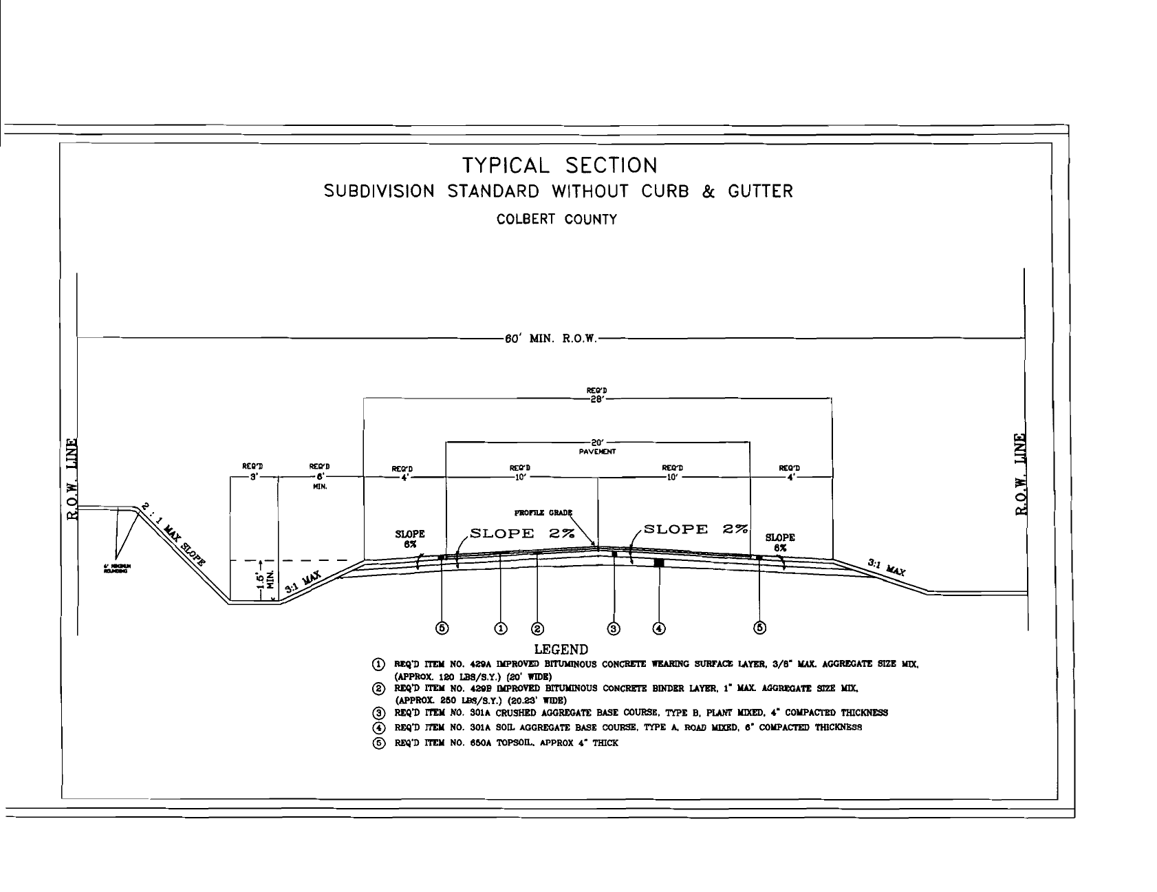
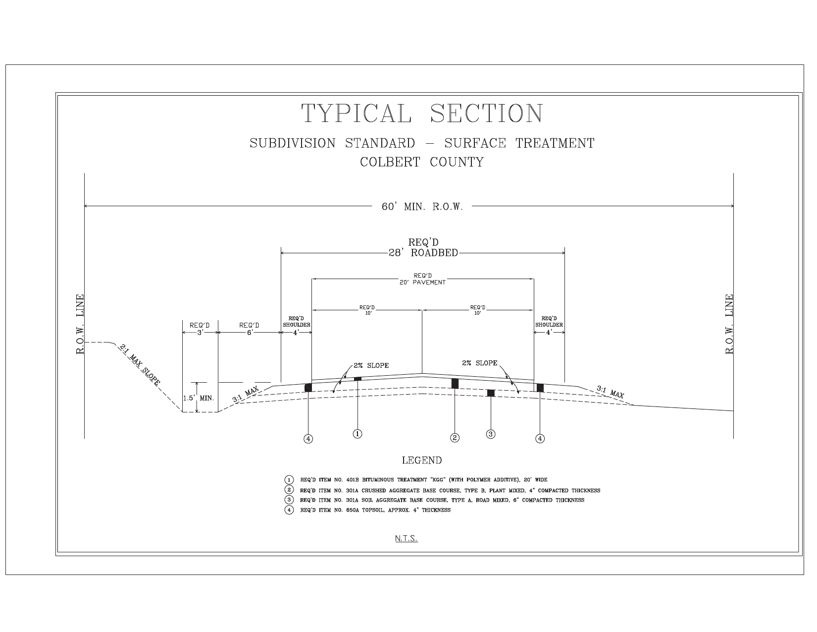
Standard Section (Ditch) - See Appendix VI
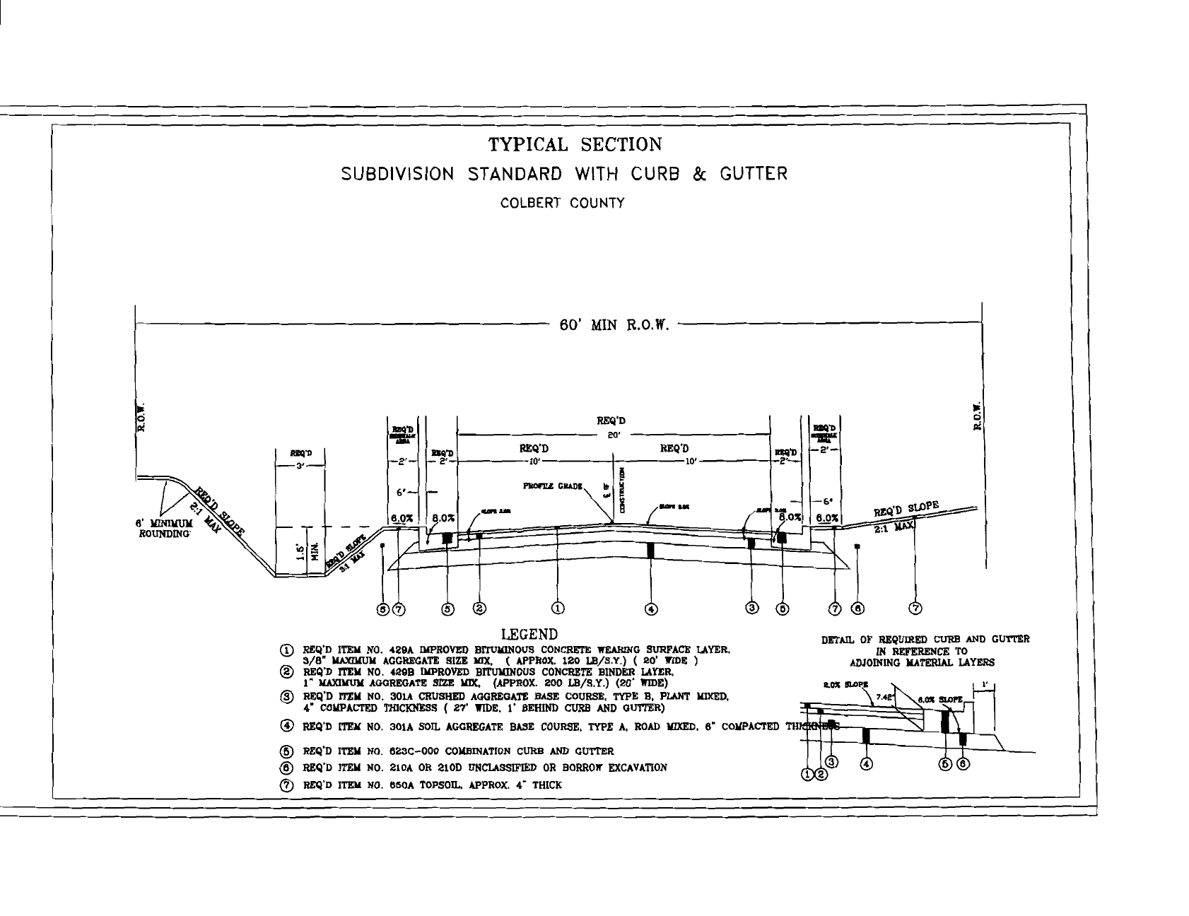
Curb Section- See Appendix VI
-
ROADS WITH LESS THAN 2500 ADT
All streets shall be designed to conform to the Alabama Department of Transportation "County Road Design Policy, Design Criteria for New and Reconstructed Roadways and Bridges with less than 2,500 ADT” (see Dot Web Site @ http://www.dot.state.al.us/ctweb/Documentation.html
-
ROADS WITH GREATER THAN OR EQUAL TO 2500 ADT
All streets shall be designed to conform to AASHTO's "A Policy on Geometric Design of Highways and Streets".
Any specifications for geometric design not covered by these regulations shall be governed by the applicable publication listed above.
All proposed subdivisions shall conform to the local Zoning Ordinances in those areas where a Zoning Ordinance is in effect. Whenever a tract to be subdivided embraces any part of a highway, street, or road so designated on any county or city regional maintenance plan, such part of such proposed public way shall be platted by the same width as indicated in the design standards. The design standards of this Article shall be the minimum standards allowable for development. Standards greater than the minimum may be required by the County Commission or the County Engineer.
The County Commission shall not grant any variance modification, or waiver of the requirements of this Article unless recommended by the County Engineer.
Section 4:01 Street Plan
- All streets shall be platted along contour elevations, which will result in minimum grades and greater visibility wherever practical, with consideration given to the anticipated use of the land.
- The proposed street layout shall be made according to good land planning practices for the type development proposed and shall be coordinated with the street systems of the surrounding areas. All streets must provide for the continuation or appropriate projection of principal streets in surrounding areas.
- The platting of any land, the purpose of which is to deny access to rights-of-way is prohibited, except as otherwise provided herein.
- Street right-of-way widths shall be dependent upon street design and classification. Adequate widths shall be provided to accommodate roadway construction and utility location. Residential subdivision streets carrying local traffic only will require a minimum sixty-foot (60’) right-of-way. Commercial or industrial subdivision will require minimum eighty-foot (80’) right-of-way; however wider rights-of-way may be required based upon examination of individual development proposals. Subdivisions along existing or dedicated or platted streets or roads where rights-of-way are inadequate shall provide additional rights-of-way to meet these minimum standards.
-
All public streets and access streets shall be paved.
Base: The minimum thickness of the base material shall be six (6) inches of soil aggregate base and four (4) inches of crushed aggregate base (pug-mill mixed) or at the developers option ten (10) inches of crushed aggregate base (pug-mill mixed) may be used. Base material shall be placed full width of the roadbed and shall be approved by the County Engineer prior to incorporation. The County Engineer may require testing of any material proposed for use as a base. This testing shall be at the expense of the developer or contractor.
Street Width: The minimum pavement widths (not including gutters) shall be twenty (20) feet. Greater pavement widths shall be required where projected traffic volumes warrant wider facilities.
Curb and Gutter: Curb and gutter may be required by the County Engineer. The purposes for requiring curbs and/or gutters are drainage control, and reduction of maintenance cost. Where curbs and gutter are required, a twenty-four (24) inch gutter with 6"curb will meet minimum standards. Valley gutter shall be used only at driveway entrances where locations are known in advance.
Asphalt Surfacing: A plant mixed type paving shall be applied to all public streets. Minimum plant mix design for all residential streets shall be as follows:
- Binder - 250 lbs. per sq. yd.
- Seal - 120 lbs. per sq. yd.
Or
Sealed Surfacing: A surface treatment identified as a "KGG". The application shall comply with the latest edition of ALDOT's "Standard Specification for Highway Construction".
Greater thickness may be required dependent upon street classification. Should any problem be encountered with the subgrade, base, or binder layers, or should much immediate construction traffic be projected following road construction, the County Engineer may require the placement of the seal course of plant mix be delayed for a minimum of six (6) months. If problems are encountered relative to pavement thickness, coring of the plant mix and base may be required. Any deficiencies found shall be corrected by the contractor / developer.
Shoulders: Shoulders shall be a minimum of two (2) feet from back of curb or four (4) feet from the edge of pavement.
Horizontal Alignment: Proposed design speeds shall be designated by the developer’s Engineer on the plan and profile sheets submitted with the proposed plans.
Intersection Sight Distance — US Customary Design Speed (mph) Distance for Left Turn Maneuver from Stop6 (ft) 10 115 15 170 20 225 25 280 30 335 35 390 40 445 45 500 6 Intersection Sight distance is measured from a point on the minor road 15 ft. from the edge of the major road pavement and measured from an eye height of 3.5 ft. on the minor road to an object height of 3.5 ft. on the major road. Guidance in determining additional sight distances is provided in AASHTO, Policy on Geometric Design of Highways and Streets.
Stopping and Passing Sight Distances — US Customary Design Speed (mph) Stopping Sight Distance (ft) Passing Sight Distance (ft) 10 47 480 15 85 585 20 115 710 25 155 900 30 200 1090 35 250 1180 40 305 1470 45 360 1625 Minimum Radius of Horizontal Curves Design Speed Min. Radius in Feet. 20 150 25 175 30 250 35 375 40 550 50 850 55 1000 - Vertical Alignment: Grades of all streets shall comply with good engineering practice. Grades shall not exceed twelve (12%) percent nor be less than one-third (0.3333%) percent. Waivers may be considered by the County Engineer only when submitted in writing by the Developers Engineer. Waivers will be considered only on minor dead end streets with low projected traffic volumes. Grades approaching intersections shall not exceed five (5%) percent for a distance of not less than one hundred (100) feet from the centerline of said intersection. Grades of cul-de-sacs shall not be more than five (5%) percent for the last one hundred (100) feet of paving.
- Sidewalks may be required where deemed necessary for public safety by the County Engineer.
- Street Alignment shall be designed to eliminate sharp curves and street jogs. No street plan will be approved with intersections, which offset less than one hundred twenty-five (125) feet between centerlines. Streets shall intersect as nearly at right angles as possible and in no case at an angle of less than sixty (60) degrees.
- Cul-de-sacs shall terminate with a property line radius of not less than sixty-six (66) feet and outside gutter radius or edge of pavement of not less than fifty (50) feet. Cul-de-sacs to accommodate school buses or other large vehicles may be required.
- Curb radii of twenty-five (25) feet or more shall be provided at the intersection of all other streets.
- Street Intersections: Deceleration and/or acceleration lanes and crossovers may be required by the County Engineer if deemed necessary to maintain a safe flow of traffic.
Section 4:02 Street Construction
- Clearing and Grubbing: All areas which will receive fill material shall be cleaned of all vegetation, trees, stumps, large rocks and other objectionable or unstable material prior to placing fill material.
- Embankment: The County Engineer or his designated agent shall determine what material is suitable for Embankment. Natural ground area shall be properly compacted prior to placing the embankment. Embankment material shall be placed in uniform lifts of ten (10) inches or less, density requirement shall be as specified under Section 306 of the current edition of the Alabama Department of Transportation’s “Standard Specifications for Highway Construction”.
- Subgrade: Finish grade shall conform to the lines, grades and cross-section as shown on the approved plan unless permission is acquired in writing from the County Engineer. The subgrade shall be shaped and compacted to one hundred (100%) percent of maximum density as determined by AASHTO T 99. The in place density will be measured for acceptance in accordance with the requirements given in AASHTO T 310, Direct Transmission Method only.
- Bases: Prior to placing any base material the subgrade shall be prepared and tested. The type material to be used for base and the required thickness shall be as stated on the approved plan. Base layers of up to six (6) inches may be placed and compacted in one (1) lift; layers exceeding six (6) inches shall be placed in approximately equal lifts not to exceed six (6) inches. Compaction shall be by vibratory steel wheel rollers or other approved rollers. Density requirement shall be as specified under Section 306 of the current edition of the Alabama Department of Transportation’s “Standard Specifications for Highway Construction”.
- Storm Design Frequencies: Closed drainage systems shall be designed on a minimum ten (10) year storm frequency, and open ditch systems shall be designed on a minimum twenty-five (25) year storm frequency.
-
Drainage Structures: Structure types shall be reinforced concrete class, metal or HDPE.
- Reinforced concrete class type structure shall be required for roadway type crossings. Metal or HDPE shall be allowed except under the roadway.
- A special design drawing will be required for any drainage structure having a required end area of twenty (20) sq. ft. or more. Reinforced concrete drainage structures shall be constructed in accordance with standard drawings and specifications approved by the County Engineer.
- Reinforced concrete pipe and arch pipe class and installation shall be in accordance with current specifications of the Alabama Department of Transportation.
- Corrugated metal pipe and arch pipe culverts shall be fully coated with asphalt with a paved invert or aluminized/galvanized coated. Gauge, corrugations and installation shall be in accordance with current specifications of the Alabama Department of Transportation.
- Minimum pipe size for closed system design shall be fifteen (15) inches and the minimum size pipe acceptable for roadway cross-drains shall be eighteen (18) inches.
- Open Channels and Ditches: Open channels and ditches shall be designed so as not to create hazardous erosion. The minimum flow line slope for paved ditches shall be 0.3333% and 0.5000% for unpaved ditches. Well defined natural drainage ways which are to be left undisturbed may be considered by the County Engineer to be utilized without any improvements, provided the drainage easement includes the complete drainage way. Where drainage areas are being constructed or natural drainage ways are disturbed, concrete lined ditches or other erosion control measures designed by the Subdivision Engineer(s) and approved by the County Engineer shall be provided. Where erosion problems arise after completion of construction, the County Engineer may require corrective measures be installed before final acceptance by the County and release of bond.
- Headwalls: Slope paved headwalls shall be installed on pipe culverts. Headwalls for precast concrete construction shall be approved by the County Engineer. Headwalls for pipe sizes larger than forty-eight (48) inches and multi-line installation shall be shown on the approved plans.
-
Combination Curb and Gutter, Valley Gutter and Sidewalks: Combination curb and gutter, valley gutter and sidewalks shall be constructed of Portland cement concrete, and shall have a compressive strength of 3000 PSI at twenty-eight (28) days. Installation shall be on a prepared subgrade and conform to the cross-section shown on the plans. The surface finish of the concrete shall have a light broomed or burlap drag texture. The edges shall be smoothed with a radius type tool.
- Transverse contraction joints shall be constructed at intervals not exceeding twenty (20) feet in combination curb and gutter and valley gutter. Joint depth shall be no less than 1/5 of the cross-section of the concrete. Sawed contraction joints shall be completed early after the concrete has set to prevent the formation of uncontrolled cracking.
- Expansion joints shall be constructed at immovable structures and at points of curvature for short radius curves. Filler material for the construction joints may be either expansion of butt type joints.
- No combination curb and gutter, valley gutter or sidewalk shall be placed on frozen or soft earth or when other unsuitable conditions exist.
- Inlets: Inlet design for storm sewer systems must be submitted with the street drainage plan for approval by the County Engineer.
- Storm Water Detention: Developments which produce an increase in the amount of storm water runoff may be required to construct storm water detention ponds or other approved types of detention devices. When required, the developer shall submit detailed engineering plans to the County Engineer including historical runoff, developed runoff, detention pond details, method of discharge, and other information as required for a review. The developer shall also include the method of maintenance for the detention pond after the development is completed.
- Erosion Control Plan: The developer shall comply with all Federal, State, and Local laws and regulations including, the Clean Water Act of 1987, the Alabama Nonpoint Source Management Program of 1989, and the regulations of the Environmental Protection Agency (EPA), and the Alabama Department of Environmental Management (ADEM). The Developer will be responsible for procuring all licenses and permits that are necessary for the development.
Section 4:03 Street and Subdivision Names
- Street names for all subdivision plats shall be subject to the approval of the Colbert County E-911 Board.
- Subdivision names for all plats shall be subject to the approval of the Colbert County Commission and shall not duplicate the name of any plat already recorded in Colbert County.
Section 4:04 Alleys, Easements, and Half Streets
- Alleys will not be permitted in residential subdivisions except as the continuation of an existing alley. Alleys shall be required in commercial or industrial districts if determined by the County Engineer that conditions necessitate alleys in the subdivision. Where alleys are permitted or required, their width shall not be less than twenty (20) feet.
- Easements shall not be less than ten (10) feet in width except in cases of double tiered lots where a width of five (5) feet from each lot will be permitted. Where there exist a storm water ditch, creek or any other such watercourse, the easement shall be of sufficient width that such watercourse may be installed and maintained efficiently. The location of any storm water ditch, creek or watercourse shall not be changed without the approval of the County Engineer.
- Half streets will not be permitted except in such cases where there exist a half street contiguous thereto. Half streets, however, will not be permitted as an extension or continuation of an existing half street.
Section 4:05 Storm Water Drainage and Grading
- All subdivisions shall be provided with adequate storm water drainage systems.
-
The platting of lots for building purposes will not be allowed in any flood plain area. Areas subject to periodic flooding or excessive flows of surface runoff will not be acceptable for development unless the subdivider makes provisions to eliminate such flooding.
- Each lot in a subdivision shall contain a flood-free building site a minimum of one (1) foot above the floor elevation of the 100-year flood projection as defined in these regulations, and outside the limits of any existing easement or the building setback lines.
-
All lots shall be graded in accordance with a grading plan approved by the County Engineer, which plan shall incorporate the following minimum requirements, except when more stringent requirements are necessary and so specified by the County Engineer.
- No lot shall shed channeled surface runoff water on to any other lot, unless such runoff is contained within an easement provided, graded and dedicated for such purpose.
- The finished slope along the bottom centerline of any lot drainage easement shall be not less than one-half percent (0.5000%).
- The side slopes of any lot drainage shall not be greater than 4 (horizontal) to 1 (vertical).
- No roadway shall shed surface runoff water on to any lot.
No subdivision or part thereof shall shed storm runoff water, either as surface runoff or an outfall from any storm sewer structure, on to any adjoining land unless such runoff is contained within an existing drainage easement, ditch, structure or right-of-way. And provided further, that such existing drainage easement, ditch, structure or right-of-way provides outfall to an established drainage channel, as approved by the County Engineer.
Section 4:06 Platting Requirements
-
Blocks:
- Blocks shall be laid out with special attention given to the type of use contemplated.
- Blocks shall be a minimum of five hundred (500) feet in length.
- Width of blocks shall be no less than three hundred fifty (350) feet.
- Blocks with lots having double frontage on streets shall not be permitted.
- The foregoing dimensions may be adjusted by the County Engineer where the type or use or nature or the topography requires such modification.
-
Lots
- Lot sizes and configurations shall be made with due regard to topographic conditions, contemplated use, and the surrounding area, no lot shall be platted that has less than sixty (60) foot of frontage on a paved road.
- Where easements for public utilities, storm or sanitary sewers are contemplated, the lot lines shall be located in such a manner as to facilitate the construction of such improvements and the maintenance thereof.
Lot area and width shall meet or exceed minimum zoning and health requirements in the area in which the property is located.
Section 4:07 Utilities
Colbert County has formally adopted the Alabama Department of Transportation's “Utility Manual” for accommodating utilities on highway rights-of-way. The location, and installation shall be in accordance with these standards and the requirements listed below.
- All subdivisions located within the service area of a public water distribution system shall have a water system designed and connected with the adjoining public water system. The number, location and spacing of fire hydrants shall be in accordance with the recommendations of the County Engineer.
- Water, gas and sanitary mains, and appurtenances if applicable, will be constructed prior to installation of paving. All mains shall be extended for service to all lots so that no subsequent cutting of pavement will be required to permit service to all lots.
- Permits for utility installation on county or proposed county rights-of-way: Any person, firm, or corporation wishing to place a utility within the road rights-of-way of Colbert County shall make application to the Colbert County Road Department on the proper prescribed utility permit forms.
- Location of all utilities shall be approved prior to placement. All utilities shall be placed in the back portion of the rights-of-way and a minimum of ten (10) feet from the edge of pavement. In areas where locations less than ten (10) feet from edge of pavement is granted then the trench shall be backfilled with an approved incompressible material (sand, slag, crushed stone or gravel etc.).
Section 4:08 Traffic Control , Signs, and Testing
- Traffic Control and Signs: All necessary signing for construction areas will be the responsibility of the Developer. Traffic control devices shall conform to the Federal Manual of Uniform Traffic Control Devices (MUTCD).
- Regulatory, Warning and Miscellaneous Signs: The Developer shall be responsible for the placement of proper signing of new streets or roads. A signing plan shall be submitted to the County Engineer for approval. Regulatory and Warning Signs shall be in accordance with the Manual on Uniform Traffic Control Devices (MUTCD). Street name signs not in accordance with the MUTCD shall not be maintained by the County.
- Notification of Work: It shall be the duty and responsibility of the developer or contractor to give notification to the County Engineer or his authorized agent, twenty-four (24) hours notice prior to starting any phase of construction and to notify the County Engineer or his authorized agent the day work is resumed after a delay for any reason. This includes all phases of construction, clearing, grading, drainage, gutters, inlets, base, surfacing and any work that pertains to the street, road or development. Failure to notify as specified may be grounds for non-acceptance.
- Inspection: The contractor and developer shall be notified of any unacceptable work found by the County Engineer or his authorized agent.
- Testing: The County Engineer shall cause such testing as he deems necessary to insure that the requirements for materials and workmanship are in accordance with these specifications, and the cost thereof shall be reimbursed by the developer. Testing shall be performed by an ALDOT approved facility.
Section 4:09 Private Subdivisions
- Improvements within proposed private subdivisions shall meet subdivision standards and the private status shall not be effective until final plat recording.
- As long as a subdivision remains private, the roads, structures, and drainage shall be maintained by the developer and/or property owners. This shall be clearly stated to those who purchase a parcel(s) within the subdivision and shall be stated in writing on each property deed. The procedure for accomplishing this shall be outlined in a letter to the Colbert County Engineer for his file.
- If a private subdivision is recorded in the Colbert County Probate Office after the effective date of these regulations and the property owners (100%) at some future date desire to eliminate the private subdivision and substitute in its place a county maintained subdivision, the owners must petition the Colbert County Commission for tentative approval. If the Colbert County Commission gives tentative approval of the petition, the owners shall submit subdivision plans to the Colbert County Engineer including improvements and repairs necessary to meet current Subdivision Regulations on the date of petition. It shall be the owners’ responsibility to have prepared a revised final plat for approval and recording in the Colbert County Probate Office.
- The Private status of the subdivision shall be clearly stated on the recorded final plat.
Article V - Required Bonds
Section 5:01 Bonds
Prior to the approval of the final plat the subdivider shall have posted bonds as provided for in this article.
Section 5:02 Improvement Bond
- A bond agreement shall be provided which states that the proposed improvements are to be installed as proposed and completed within a specified length of time as determined by the Colbert County Engineer. Said bond shall be made by a surety company authorized to do business in the State of Alabama. The applicant shall not be released from said bond except by release in writing from the County Engineer and shall be subject to the administrative procedures established by the County Commission on behalf of the Colbert County.
- The bond amount shall be set at one hundred and fifty (150%) percent of the estimated cost of the improvements. A schedule of estimated costs for all items to be bonded shall be submitted by a registered engineer for review by the Colbert County Engineer. This schedule shall clearly describe the items, quantities, unit cost and total cost of the proposed improvements.
Section 5:03 Maintenance Bond
- The County Engineer shall secure from all developers a statement in which said developer shall agree to maintain all improvements for a period of one (1) year after the acceptance of such improvements by the County Commission.
- A maintenance bond shall be required prior to recording of final plat in the Colbert County Probate Office. Said bond shall be made by a surety company authorized to do business in the State of Alabama. The applicant shall not be released from said bond except by release in writing from the County Engineer and shall be subject to the administrative procedures established by the County Commission on behalf of the Colbert County.
- The bond amount shall be set at one hundred and twenty-five (125%) percent of the cost of the improvements. A schedule of cost for all items to be bonded shall be submitted by a registered engineer for review by the Colbert County Engineer. This schedule shall clearly describe the items, quantities, unit cost and total cost of the proposed improvements.
Article VI - Variances
Section 6:01 Modifications, Variances, and Waivers
If it be determined that strict compliance with these regulations should result in extraordinary hardship to the subdivider due to unusual topography or conditions beyond the control of the subdivided, then the County Commission, except as provided in Article IV, may modify, vary or waive such requirements provided that such modification, variance, or waiver will not tend to injure or place the public health, safety or welfare in jeopardy, nor nullify the stated or implied intent or purpose of these regulation, and provided further that such modification, variance, or waiver and the reason therefore shall be entered upon the minutes of the County Commission.
Section 6:02 Conditions of and Applications for Variances
- In granting modifications, variances or waivers, the County Engineer may attach such other reasonable conditions as will, in its judgment, justify such modifications, variances or waivers and still maintain substantially the objectives of these regulations.
- Each and every modification, variance, or waiver of these regulations sought by a subdivider shall be specially applied for, in the numerical order of these regulations, in writing by the subdivider and submitted to the County Engineer which shall forward a copy of said application to the Colbert County Commission with his recommendation prior to a regular scheduled meeting of the Commission. Any condition shown on the preliminary or final plat or on engineering plans or data called for by Article II, Section 2:03 which would require a modification, variance or waiver shall constitute a ground for disapproval of the proposed or final plat unless such special application for modification, variance or waiver is made.
Appendix I - Sample Certificates
Example A
(Proposed Plat)
CERTIFICATE OF ENGINEERING DESIGN BY A PROFESSIONAL ENGINEER
I, ___________________________ a professional engineer licensed in the State of Alabama, License Number ________________, do hereby certify that the streets and drainage system for ____________________________________ Subdivision have been designed under my supervision.
I further certify that the drainage system has been designed to meet the _______ year storm criteria. This design will ensure that all drainage waters occurring during a storm of less than _______ year storm magnitude will flow within the rights-of-way or drainage easements indicated as such on the official plat for this subdivision.
I further certify that the streets are designed for a design speed of __________ to meet applicable design criteria for safety, geometry, profile, and typical sections according to the Alabama Department of Transportation's "County Road Design Policy!"
- NAME
- ______________________________________
- P.E.#
- ______________________________________
- TITLE
- ______________________________________
- DATE
- ______________________________________
** Refer to Article IV for correct design criteria depending on ADT.
Example B
(Final Plat)
SURVEYOR’ S CERTIFICATE AND DESCRIPTION OF LAND PLATTED
STATE OF ALABAMA
COUNTY OF COLBERT
I, (name of surveyor), a Licensed Professional Land Surveyor in the State of Alabama, for (Survey Company) state that this is a plat of an actual field survey of lots ____ through _____, inclusive of (Name of Subdivision) more particularly described as follows:
DESCRIPTION
(Out boundary Description)
I further state that this survey and plat meets the Minimum Technical Standards as set forth by the Alabama State Board of Licensure for Professional Engineers and Land Surveyors in Rule 330-X-14-.05 (G) on March 31, 1990 (or most current revised rule) to the best of my knowledge, information and belief.
This the __________________________ day of ___________,20______.
_(Signature of Surveyor)_
_(Typed Name of Surveyor)
Alabama License #______________________
Note: One of the following notary's acknowledgments must appear for each Surveyor's Certificate (see example E-1 and E-2). Surveyor's name should be used in the Acknowledgement.
Example C
(Final Plat)
ENGINEER’ S CERTIFICATE OF ENGINEERING DESIGN AND CONSTRUCTION
I, _____________________________, a professional engineer licensed in the State of Alabama, License Number _________________ do hereby certify that the streets and drainage system for ___________________________________ Subdivision have been designed and constructed under my supervision in accordance with the construction plans submitted to the County Engineer.
I further certify that the drainage system has been designed and constructed to meet the _______ year storm criteria. This design will ensure that all drainage waters occurring during a storm of less than _______ year storm magnitude will flow within the rights-of-way or drainage easements indicated as such on the official plat for this subdivision.
I further certify that the streets are designed and constructed for a design speed of _________ to meet applicable design criteria for safety, geometry, profile, and typical sections according to the Alabama Department of Transportation's "County Road Design Policy.""
I further certify that I have checked all test reports and that all base material, concrete, and asphalt have been installed in accordance with the typical sections, profiles and plan details and meet minimum requirements as set out in the most current edition of the State of Alabama Department of Transportation’s Standard Specifications for Highway Construction.
I further certify that all Federal and State permits required for construction of the subdivision were obtained and complied by during construction.
- NAME
- ______________________________________
- P.E.#
- _______________________________________
- TITLE
- _______________________________________
- FIRM
- _______________________________________
- DATE
- ________________________________________________
** Refer to Article IV for correct design criteria depending on ADT.
Example D
(Final Plat)
DEDICATION
I, ____________________________________, the owner(s) of said land(s) surveyed by (Name of Surveyor), do hereby certify that title was and is vested in said owner(s) and join in the foregoing statement made by said (Name of Surveyor), and as stated in Code of Alabama 1975, § 35-2-50 et seq., do hereby certify that it was and is my (our) intention to divide said lands into lots as shown by said plat and do hereby dedicate, grant, and convey for public use the streets, alleys and public grounds as shown on said plat.
Signed and sealed in the presence of:
____________________________________
Property Owner
Note: One of the following notary's acknowledgments must appear for each Dedication Certificate (see example E-1 and E-2). Owner's name should be used in Acknowledgement.
In cases where a subdivision is to remain private, the above dedication (Example D) shall state that the "streets, alleys, and public grounds shall remain private grounds as shown on said plat."
Example E-1
(STATE OF ALABAMA)
(COUNTY OF COLBERT)
ACKNOWLEDGMENT
I, _________________________, Notary Public in and for said County, in said State, hereby certify that (corporate officers name), whose name as (title) of the (corporation name), is signed to the foregoing instrument, and who is known to me, acknowledged before me on this day that, being informed of the content of the instrument, he/she as such officer and with full authority, executed the same voluntarily for and as the act of said corporation.
GIVEN under my hand and official seal this _________ day of ________, 20_________.
_________________________________
NOTARY PUBLIC
Example of E-2
(STATE OF ALABAMA)
(COUNTY OF COLBERT)
ACKNOWLEDGMENT
I, ________________________________,Notary Public in and for said County, in said State, hereby certify that (owner's or surveyor's name), whose name is signed to the foregoing instrument, and who is known to me, acknowledged before me on this day that, being informed of the content of the instrument, executed the same voluntarily.
GIVEN under my hand and official seal this _____________ day of _______, 20_____.
_____________________________________
NOTARY PUBLIC
Example F
(Final Plat)
CERTIFICATE OF APPROVAL BY THE
(insert name of electric utility)
The undersigned, as authorized by the (name of electric utility) hereby approved the within plat for the recording of same in the Probate Office of Colbert County, Alabama, this _______ day of _________, 20_____.
____________________________________
(Electric utility authorized signature)
Example G
(Final Plat)
CERTIFICATE OF APPROVAL BY THE
( insert name of water and sewer, if available, utility)
The undersigned, as authorized by the (name of water and sewer utility) hereby approved the within plat for the recording of the same in the Probate Office of Colbert County, Alabama, this the _______ day of ____________, 20_______.
____________________________________
(water and sewer utility authorized signature)
Example H
(Final Plat)
CERTIFICATE OF APPROVAL BY THE COUNTY ENGINEER
The undersigned, as County Engineer of the County of Colbert, Alabama, hereby certifies approval of this plat for the recording of same in the Probate Office of Colbert County, Alabama, this ______ day of __________, 20____.
________________________________________
County Engineer
County of Colbert, Alabama
Example I
(Final Plat)
CERTIFICATE OF APPROVAL BY THE COLBERT COUNTY HEALTH DEPARTMENT
The undersigned, as authorized by the Colbert County Health Department, State of Alabama hereby certifies this subdivision meets the approval of the Colbert County Health Department subject to certain conditions of approval and/or lot deletions on file with the said health Department, which conditions are made a part of this approval as if set out hereon. I hereby approve the within plat for the recording of same in the Probate Office of Colbert County, Alabama, this ____ day of __________, 20______.
________________________________
Health Officer
Example J
APPLICATION FOR AUTHORITY TO SECURE PRE-SALE AGREEMENTS
Pursuant to Ala. Code § 11-24-1.1 and Section 2:01(a) of the Colbert County subdivision regulations, I/we, ________________________, (name of applicant developer) hereby request authority to secure pre-sale agreements from prospective buyers of lots or houses to be included in a proposed subdivision development project to be known as the ___________________________ ______________________________________________ (insert name of proposed development).
The proposed subdivision development project will be located at: ________________________________________________________________________________________________________________________________________________________________________________________________________________________________________________
(insert exact location and description of the property)
The proposed subdivision development property is owned by: ____________________________________________________________________________________________________________
(insert name or names of legal property owner(s))
I/we have submitted a sketch plan of the proposed subdivision as part of this application in compliance with Section 2:01(a) of the county subdivision regulations. I/we anticipate submitting a proposed plat for approval in approximately ____________ months.
I/we are making this request for the following reasons (set out reasons in detail):
________________________________________________________________________________________________________________________________________________________________________________________________________________________________________________________________________________________________________________________________________________________________
A resume including references and listing of my/our previously completed subdivision development projects is attached. I/we agree to provide any additional information requested by the Colbert County Engineer to supplement this application. I/we can be contacted as follows:
- Business address
- ____________________________________________________________ ____________________________________________________________
- Telephone
- _____________________ (business) _________________________ (cell)
- ____________________________________________________________
I/we understand that, in the event authorization to secure pre-sale agreements from prospective buyers of lots or houses in the proposed subdivision development is granted, all pre-sale agreements shall clearly state that there can be no final sale of property until and unless all requirements of Ala. Code § 11-24-2 and the county subdivision regulations have been fulfilled.
I/we understand that, unless an extension of time is granted by the Colbert County Engineer, the authorization to secure pre-sale agreements as provided herein shall be revoked by operation of law six months after the date authorization is granted.
I/we understand that, pursuant to Ala. Code § 11-24-1.1 and Section 2:01(a) of the county subdivision regulations, I/we shall notify the Colbert County Engineer in writing once financing for this subdivision development has been secured. I/we also understand that, once financing is secured and before any work is performed on the subdivision development project, I/we shall comply with the county subdivision regulations’ process for approval of the proposed subdivision plat and obtaining a permit to develop. I/we further understand that no final sale of any property, including property that is the subject of a pre-sale agreement secured pursuant to authority granted by approval of this application until and unless I/we have complied with all requirements of Ala. Code § 11-24-2 and the county subdivision regulations.
Request for approval submitted on this the ______ day of ________________, 20__.
_________________________________
_________________________________
Appendix II - Subdivision Flowchart / Sample Forms
Colbert County Subdivision Flowchart
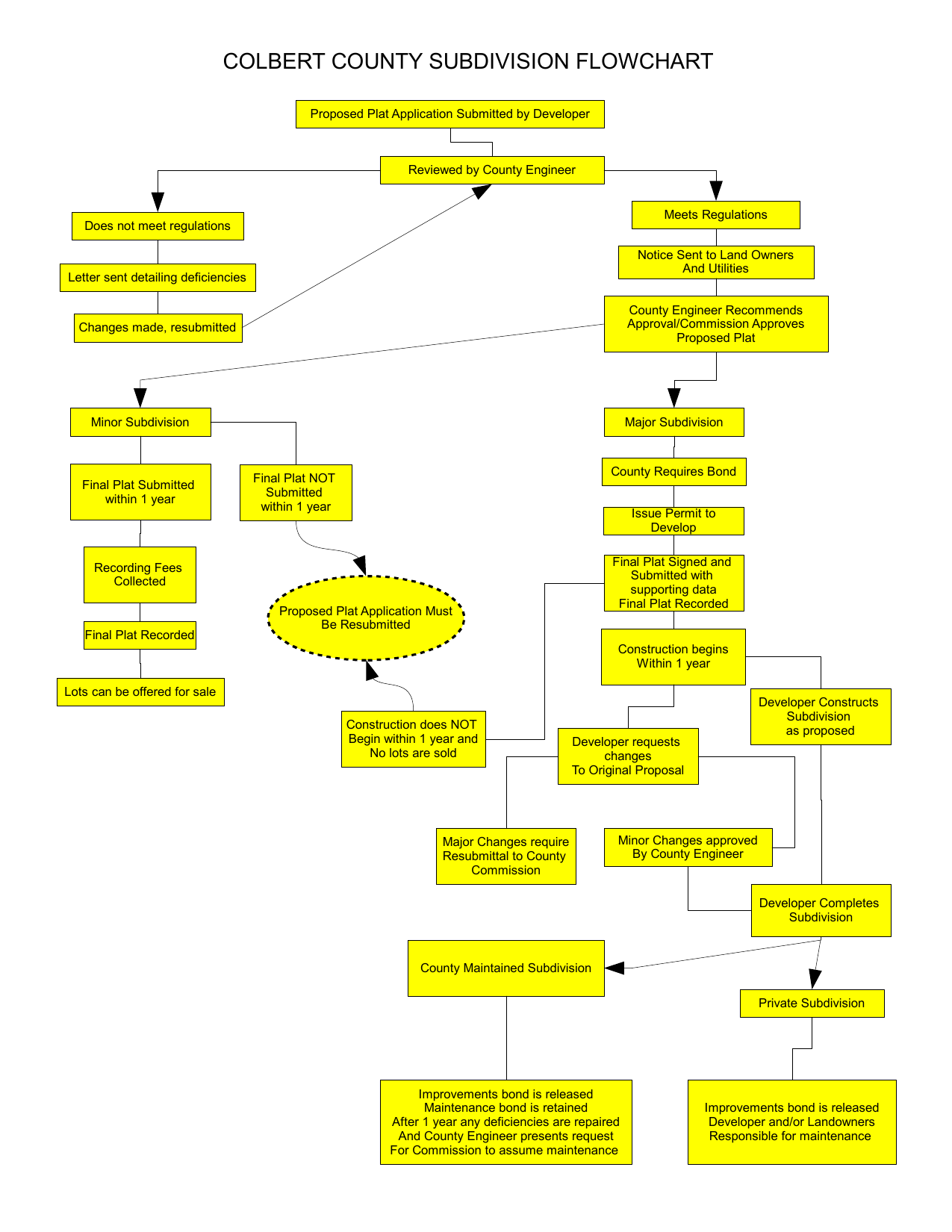
Initial review
- Proposed Plat Application Submitted by Developer.
- Reviewed by County Engineer.
- If the application does not meet regulations: Letter sent detailing deficiencies; changes made, resubmitted; application returns to review by County Engineer.
- If the application meets Regulations: Notice Sent to Land Owners And Utilities; County Engineer Recommends Approval/Commission Approves Proposed Plat.
Minor Subdivision path
- Final Plat Submitted within 1 year → Recording Fees Collected → Final Plat Recorded → Lots can be offered for sale.
- Final Plat NOT Submitted within 1 year → Proposed Plat Application Must Be Resubmitted.
Major Subdivision path
- County Requires Bond.
- Issue Permit to Develop.
- Final Plat Signed and Submitted with supporting data; Final Plat Recorded.
- Construction begins Within 1 year.
- If construction does NOT Begin within 1 year and No lots are sold → Proposed Plat Application Must Be Resubmitted.
- Developer Constructs Subdivision as proposed.
- Developer requests changes To Original Proposal:
- Major Changes require Resubmittal to County Commission.
- Minor Changes approved By County Engineer.
- Developer Completes Subdivision.
- County Maintained Subdivision: Improvements bond is released; Maintenance bond is retained; After 1 year any deficiencies are repaired And County Engineer presents request For Commission to assume maintenance.
- Private Subdivision: Improvements bond is released; Developer and/or Landowners Responsible for maintenance.
Application for Proposed Plat Review
DATE: ________________________
- Name of Subdivision ______________________________________________________
- Name of Applicant _______________________________ Phone _______________
Address _____________________________________________________________ - Owner of Record ____________________________________________________
Address _________________________________________ Phone _______________ - Engineer __________________________________________________________
Address _________________________________________ Phone _______________ - Land Surveyor ________________________________________________________
Address ________________________________________ Phone _______________ - Attorney ______________________________________ Phone _____________
Address ______________________________________________________________ - Subdivision Location:
____________________________________________________________________
____________________________________________________________________
____________________________________________________________________
____________________________________________________________________
____________________________________________________________________ - Total Acreage ___________ Number of lots ________________________
- Proposed Road Names — Length — Width of Pavement
Proposed Road Names Length Width of Pavement _____________________ _____ _____________ _____________________ _____ _____________ _____________________ _____ _____________ _____________________ _____ _____________ - Has this plan been before the Commission in the past? _______ If yes, have any changes been made since this plans was last before the Commission? __________
If so, describe the changes
____________________________________________________________________
____________________________________________________________________
____________________________________________________________________
____________________________________________________________________ - List all adjacent property owner(s) name and addresses.
- __________________________________________________________________
- __________________________________________________________________
- ___________________________________________________________________
- ___________________________________________________________________
- ___________________________________________________________________
- __________________________________________________________________
- ___________________________________________________________________
- ___________________________________________________________________
list additional owners on separate sheet if necessary
- Attach eight (8) copies of proposed plat.
- Attach two (2) copies of construction plans.
Appendix III - Amendments
Amendment 1
Effective: April 18, 2007
Section 4:02 (6) shall be deleted in its entirety and replaced with the following:
-
Drainage Structures: Structure types shall be reinforced concrete class, metal or HDPE.
- Reinforced concrete class type structure shall be required for roadway type crossings. Metal or HDPE shall be allowed except under the roadway.
- A special design drawing will be required for any drainage structure having a required end area of twenty (20) sq. ft. or more. Reinforced concrete drainage structures shall be constructed in accordance with standard drawings and specifications approved by the County Engineer.
- Reinforced concrete pipe and arch pipe class and installation shall be in accordance with current specifications of the Alabama Department of Transportation.
- Corrugated metal pipe and arch pipe culverts shall be fully coated with asphalt with a paved invert or aluminized/galvanized coated. Gauge, corrugations and installation shall be in accordance with current specifications of the Alabama Department of Transportation.
- Minimum pipe size for closed system design shall be fifteen (15) inches and the minimum size pipe acceptable for roadway cross-drains shall be eighteen (18) inches.
Amendment 2
Effective: June 19, 2007
Section 4:02 (4) shall be deleted in its entirety and replaced with the following:
-
Bases: Prior to placing any base material the subgrade shall be prepared and tested. The type of material to be used for base and the required thickness shall be as stated on the approved plan. Base layers of up to six (6) inches may be placed and compacted in one (1) lift; layers exceeding six (6) inches shall be placed in approximately equal lifts not to exceed six (6) inches. Compaction shall be by vibratory steel wheel rollers or other approved rollers. Density requirements shall be as specified under Section 306 of the current edition of the Alabama Department of Transportation’s “Standard Specifications for Highway Construction”.
Thickness requirements for bituminous pavement layers shall be dependent upon street classification. Density requirements shall be as specified under Section 306 of the current edition of the Alabama Department of Transportation’s “Standard Specifications for Highway Construction”.
Amendment 3
Effective: February 5, 2008
Section 2:03 An Item 10 shall be added for clarification of documents required for submittal of proposed plat.
- Engineer’s Certificate
Amendment 4
Effective: June 4, 2008
Section 1:05 Definitions Add the following:
Planned Development – A subdivision of land consisting of one or more buildings, sites, or units which is not subdivided into customary lots, blocks, or streets and thus is contained on one common parcel. This type of development shall not only be on a common parcel but shall also have a common owner who shall be responsible for all infrastructure and drainage within the development. A building footprint shall be the maximum boundary allowed to be transferred, sold, or leased in this type of development.
Make the following changes:
Subdivision, Major – All subdivisions or Planned Development not classified as a minor subdivision.
Subdivision, Minor – Any subdivision or Planned Development with parcels or lots five (5) acres or less fronting on an existing county road that does not involve any new street (or road) or the extension of public utilities and does not require the creation of any public improvements, and does not, in the opinion of the developer’s licensed engineer with the concurrence of the County Engineer, create any additional storm water runoff.
Section 2:09 Make the following changes:
- Approval Required. All subdivisions and Planned Developments shall be subject to the provisions of these regulations and subject to the approval in accordance with this section. No development activity or sale of land subdivided shall proceed without written approval in accordance with these regulations.
Section 3:01 Make the following changes:
- Lot lines, lot and block numbers, unit numbers, and approximate dimensions
Article IV. Design Standards Add the following:
A Planned Development, which consists of multiple buildings, sites, or units on a common parcel of land, shall be required to be approved by the County Commission. These types of developments are defined in Section 1:05 and are subject to the county’s Subdivision Regulations. The county may require additional items to be addressed depending on the scope and size of the development. Documentation shall be provided showing common ownership and maintenance responsibilities for the types of developments.
Amendment 5
Effective: July 1, 2008
Article IV. Design Standards Delete the following:
A Planned Development, which consists of multiple buildings, sites, or units on a common parcel of land, shall be required to be approved by the County Commission. These types of developments are defined in Section 1:05 and are subject to the county’s Subdivision Regulations. The county may require additional items to be addressed depending on the scope and size of the development. Documentation shall be provided showing common ownership and maintenance responsibilities for the types of developments.
Section 2:09 (1) Replace with the following:
Approval required. All subdivisions shall be subject to the provisions of these regulations and subject to approval in accordance with this section. No development activity or sale of land subdivided shall proceed without written approval in accordance with these regulations.
A Planned Development, which consists of multiple buildings, sites, or units on a common parcel of land, shall be required to be approved by the County Commission. These types of developments are defined in Section 1:05 and are subject to the county’s Subdivision Regulations. The county may require additional items to be addressed depending on the scope and size of the development. Documentation shall be provided showing common ownership and maintenance responsibilities for the types of developments.
Amendment 6
Effective: June 3, 2014
- Section 1:05 Added definition for Pre-Sale Agreement
- Section 2:01 Edited to adjust for Pre-Sale Agreement
- Section 2:06 Edited to meet requirements of Pre-Sale Agreement Law
- Section 2:08 (1) Added "or upon completion and acceptance of the proposed construction
- Section 2:09 (1) Added "and planned developments"
- Section 2:09 (2) Added that exemption from Sub Regs does not imply exemption from Floodplain Ordinance
- Section 3:01 (1) Added items i-m, p-s, and u-aa
- Section 3:01 (2) Created (2) from (1), added a
- Section 3:03 (1) Replaced c with " Where a street or alley has been vacated, a note shall be shown on the plat indicating such and referring to the instruments of vacation by deed book and page number, removed d
- Section 4:08 Added "Testing" to this section, added item (5)
- Appendix 1 Added Example J
- Appendix 2 Updated Flow Chart
Amendment 7
Effective: July 15,2014
Section 4:01 Added
Or
Sealed Surfacing: A surface treatment identified as a "KGG". The application shall comply with the latest edition of ALDOT's "Standard Specification for Highway Construction".
Appendix IV - Acceptance of Roads for Maintenance
Alabama Law requires that all streets and roads be accepted for maintenance by the County Commission by separate resolution of the County Commission. If the developer desires to have the County assume the responsibility for the maintenance of roads located within the development the following conditions must be met.
- The developer must make a written request to the County Commission requesting that the Commission accept the roads within the subdivision for maintenance. This request should be made at the time of the submission of the proposed plat application
- The developer must guarantee by bond any necessary repairs for a period of one (1) year from completion of construction.
- In order for any road to be considered for acceptance of maintenance by Colbert County it shall connect to a paved, state, county or city maintained highway, road or street.
- All roads necessary to provide access between an existing paved, state, county or city maintained highway, road or street and a proposed major subdivision shall be constructed to meet current subdivision regulations.
Appendix V - Applicable State Laws
County Subdivision Regulations Law
§ 11-24-1 - Definitions; regulation of lots, streets, drainage, utilities, etc.; developer to reimburse utility for uneconomical placement.
-
When used in this chapter, the following words shall have the following meanings:
- COUNTY. A political subdivision of the state created by statute to aid in the administration of government
- COUNTY COMMISSION. The chief administrative or legislative body of the county.
- STREETS. Streets, avenues, boulevards, roads, lanes, alleys, viaducts, and other roads.
- SUBDIVISION. The development and division of a lot, tract, or parcel of land into two or more lots, plats, sites, or otherwise for the purpose of establishing or creating a subdivision through the sale, lease, or building development. Development includes, but is not limited to, the design work of lot layout, the construction of drainage structures, the construction of buildings or public use areas, the planning and construction of public streets and public roads, and the placement of public utilities. A subdivision does not include the construction or development of roads or buildings on private property to be used for agricultural purposes.
- The county commission or like governing body of each county in the state shall be authorized to regulate the minimum size of lots, the planning and construction of all public streets, public roads, and drainage structures and require proper placement of Public utilities to be located in proposed subdivisions of land or in proposed additions to subdivisions of land existing at the time of the enactment of this chapter where the subdivisions are situated outside the corporate limits of any municipality in the county. The placement of public utilities shall not be inconsistent with the requirements of the Southern Standard Building Code, state and federal laws, and regulations of state and federal regulatory agencies. If the county commission or like governing body of any county shall require the placement of public utility facilities in any subdivision or addition thereto in a manner which is other than the most economical method available from an engineering standpoint, then the developer of the subdivision or addition shall reimburse the utility for the difference in cost between the method so required by the county governing body and the most economical method available.
- The county commission or like governing body of each county in the state may establish a board of developers to make suggestions to the commission regarding the development and division of subdivisions. The board may advise the commission on the contents of the regulations, revisions that need to be made to the regulations, and assist in resolving disputes between the commission and developers.
§ 11-24-2 - Developer to conform with chapter, post bond, submit plat for approval, etc.; county engineer and utility to review plat before approval.
-
It shall be the duty of the owner and developer of each subdivision to have all construction completed in conformity with this chapter and, prior to beginning any construction or development, to submit the proposed plat to the county commission for approval and obtain a permit to develop as required in this section. The permit to develop shall be obtained before the actual sale, offering for sale, transfer, or lease of any lots from the subdivision or addition to the public, it must include a plan to deliver utilities including water, and shall only be issued upon approval of the proposed plat by the county commission. As a condition for the issuance of a permit, the county commission may require any of the following for approval of the proposed plat:
- The filing and posting of a reasonable surety bond with the county commission by the developers of the proposed subdivisions or proposed additions to guarantee the actual construction and installation are in accordance with approved plans for public streets, public roads, drainage structures, and public utilities.
- The names and addresses of each adjoining landowner and utility subject to the notice as provided in subsection (b).
- A permit fee, which shall not exceed twenty-five dollars ($25).
- No proposed plat shall be approved or disapproved by the county commission without first being reviewed by the county engineer or his or her designee. Following the review, the county engineer or his or her designee shall certify to the commission whether the proposed plat meets the county’s regulations. If the proposed plat meets the regulations, it shall be approved by the commission. Should the proposed plat be determined by the county engineer to be deficient in any regard, the county engineer shall detail the deficiency to the county commission along with a recommendation that it be disapproved. Notice of the recommendation of the engineer shall be sent to the owner or developer whose name and address appears on the submitted proposed plat by registered or certified mail at least 10 days before the recommendation shall be presented to the county commission for action. A similar notice shall be mailed to the owners of land immediately adjoining the platted land as their names appear upon the plats in the office of the county tax assessor and their addresses appear in the directory of the county or on the tax records of the county and to each utility affected thereby. Each utility notified in writing by the commission shall be given at least 10 days to review the proposed plat and submit a written report to the commission as to whether all provisions affecting the service to be provided by the utility are reasonable and adequate. If any utility affected by the proposed plat is not properly notified then the approval or disapproval by the county commission shall not be valid until the affected utility has been given at least ten days' notice prior to such approval or disapproval as provided by this subsection.
- In addition to the foregoing, once the owner or developer of all proposed subdivisions or proposed additions to existing subdivisions of land situated outside the corporate limits of any municipality in the county has met all requirements of the county's regulations, he or she shall submit the final plat of the developed subdivision or addition to existing subdivision to the county engineer for signature verifying that the subdivision or additions to existing subdivision meets the county’s regulations. After the final plat has been signed by the county engineer, it shall be filed for record or received for filing in the office of the judge of probate. Subject to the penalties set out in Section 11-24-3, it shall be a violation of this chapter for the developer to file or to have filed any plat, deed, property description, or document of property transfer without full compliance with this section.
- Notwithstanding the provisions of subsections (a), (b), and (c), this section shall not apply to the sale, deed, or transfer of land by the owner to an immediate family member, except that, in the event that there is any sale, deed, or transfer of land by the owner or an immediate family member to someone other than an immediate family member, this chapter shall then apply to any subdivision of property as defined in subdivision (4) of Section 11-24-1.
§ 11-24-3 - Fines; county to enjoin action, employ inspectors/charge inspection fees.
- Any owner or developer falling to comply with the permitting requirement or otherwise violating this chapter or any rule or regulation made pursuant to this chapter shall be fined one thousand dollars ($1,000) per lot that has been sold, offered for sale, transferred, or leased to the public.
- In the event that the developer or owner fails to comply with this chapter, the county commission shall have the right to enjoin action of the developer or owner by a civil action for the injunction brought in any court of competent jurisdiction or, in the event that work on the subdivision has been completed, to bring action to compel the developer or owner to comply with this chapter. In addition to injunction, the county commission may recover the penalty as provided by this section in any court of competent jurisdiction.
- The county commission may employ inspectors and may request the county license inspector to see that its rules and regulations are not violated and that the plans and specifications for the minimum size of lots, the planning and construction of public streets, public roads, and drainage structures, and the placement of public utilities are not in conflict with the rules and regulations of the county. The county commission may charge inspection fees, not to exceed actual costs, to be paid by the owners of the property inspected.
- This chapter may be enforced by the county license inspector under Section 40-12-10, including issuing citations as provided in subsection (j) of Section 40-12-10 for failure to properly obtain the permit to develop required pursuant to subsection (a) of Section 11-24-2. The license inspector may issue subsequent citations for failure to properly obtain a permit to develop if, after 30 days following the issuance of the previous citation for the same violation, the owner or developer of the subdivision has not made proper application for a permit pursuant to the requirements of this chapter. The applicable fines set out in subsection (a) shall be doubled and separately assessed against the owner or developer of the subdivision for each subsequent citation issued by the license inspector as provided herein"
§ 11-24-4 -Chapter not to impair utilities right of eminent domain, etc.
This chapter shall not be construed to impair the right of eminent domain granted heretofore or hereafter by the laws of this state to utilities, whether public or private, or their right to exercise authority conferred by statutes, franchises, certificates of convenience and necessity, licenses or casements.
§ 11-24-5 - No jurisdiction within organized municipal planning commission.
No county shall exercise jurisdiction under provisions of this chapter within the jurisdiction of any municipal planning commission presently organized and functional or which shall become organized and functional within six months of the date the county assumes such jurisdiction by publishing and adopting notice thereof.
§ 11-24-6 - County and municipality agreement as to exercise of jurisdiction.
It is the intent of the legislature that all proposed subdivisions be subject to regulation, and counties and municipalities affected by provisions of this chapter shall have authority to reach and publish agreement as to exercise of jurisdictional authority over proposed subdivisions, which agreement shall be published once a week for two consecutive weeks in a newspaper of general circulation in the county and affected municipality and such agreement shall thereafter have the force and effect of law.
§ 11-24-7 - Chapter cumulative-, not to repeal any local laws.
The provisions of this chapter are cumulative and shall not repeal any local law or general law of local application granting similar or additional duties and authority to any county commission.
Territorial Jurisdiction of Municipal Planning Commission
§ 11-52-30 - Territorial jurisdiction of municipal/county planning commissions and county commissions as to subdivisions; approval of maps or plats of subdivisions.
- The territorial jurisdiction of any municipal planning commission over the subdivision of land shall include all land located in the municipality and all land lying within five miles of the corporate limits of the municipality and not located in any other Municipality; except that, in the case of any such land lying within five miles of more than one municipality having a planning commission, the jurisdiction of each such municipal planning commission shall terminate at a boundary line equidistant from the respective corporate limits of such municipalities; provided further, that in all counties having a population of 600,000 or more according to the 1950 federal census or any succeeding decennial federal census, the county planning and zoning commission shall be invested with such authority, except and unless the municipality or municipalities in question is/are actively exercising zoning jurisdiction and control within said police and/or five mile jurisdiction or, in the case of a municipality subsequently incorporated, within 180 days from the date of its incorporation; provided, further, that in all counties having a population of 600,000 or more inhabitants according to the 1950 federal census Or any succeeding decennial federal census, the county commission of such county shall have the right and power to establish minimum specifications and regulations governing the lay-out, grading and paving of all streets, avenues and alleys and the construction or installation of all water, sewer or drainage pipes or lines in any subdivision lying wholly or partly in areas outside the corporate limits of any municipality in such counties and relating to subdivisions lying within the corporate limits of any municipality in such counties which has declined or failed to exercise zoning jurisdiction and control as provided in this section.
- No map or plat of any subdivision shall be recorded, and no property shall be sold referenced to such map or plat, until and unless it has been first submitted to and approved by the county engineer or, in his absence, by the acting county engineer of such county, who shall examine same for compliance with the specifications and regulations of the county commission of such county are if it is in compliance, shall note his approval on such map or plat by noting thereon "approved," giving the date of such approval and signing same in his official capacity.
Where any subdivision lies within the extraterritorial planning jurisdiction of any municipality having exercised said extraterritorial jurisdiction, the requirement for approval of improvements in said subdivision by the county engineer shall in no way diminish, waive or otherwise lessen the requirements of such municipality. The more strict requirements, whether of the municipality or of the county, must be complied with by the developer. Approval by the county engineer shall in no way constitute approval in lieu of or on behalf of any municipality with respect to subdivisions lying within its extraterritorial planning jurisdiction. All such maps or plats must be first submitted to and approved by the municipal planning commission or other appropriate municipal agency.
County License Inspector
§ 40-12-10 -- License inspectors generally; when taxes due and payable; collection and distribution of penalties and citation fees on delinquent licenses.
- The county commission of each county is hereby authorized and empowered to appoint a license inspector.
- It shall be the duty of the license inspector to scrutinize the records and stubs kept in the office of the probate judge and also to examine the license records of each city or town located in the county or counties of which he has been appointed license inspector; and, if it shall be reported to any license inspector or come to his knowledge that any person, persons, firms, or corporations have failed or refused to take out a license for a business or occupation for which a license is required by the state or have failed or refused to take out a license for operating any motor vehicle or trailer for winch a license is required by law, the license inspector shall thereupon cite such delinquent to appear before the license inspector at the courthouse of the county in which such citation is issued and to show cause why the license or privilege tax required by law has not been paid and, at the same time, shall file with the probate judge of the county a copy of such citation showing service on the delinquent.
- If the license inspector shall discover any motor vehicle being operated without a proper or legal license, he shall cite the operator of the motor vehicle; and, in filing copy of such citation with the probate judge, he shall show on such citation the particular motor vehicle operated without legal license, as well as the operator thereof
- The probate judge must in all cases, in addition to the other penalties required to be collected by him, collect the citation fee, if any, before issuing any license; and, in case of a motor vehicle where a license is taken out in the name of person not cited, the citation fee shall be collected if the citation filed shows the motor number of such vehicle. When any license is due the license inspector shall cause the delinquent to appear before the probate judge of the county and take out the same, bid such probate judge shall not have the authority to determine the liability of such delinquent for such license and shall in each case issue a license to the applicant upon the payment by him of the amount or amounts prescribed by this title. If such delinquent shall fail or refuse to take out a license, the license inspector shall institute or cause to be instituted criminal proceedings against such delinquent before any court having jurisdiction of such offense. In case of emergency the license inspector must commence the criminal proceedings in the first place.
- All license taxes levied by this title, except as otherwise provided, shall be due and payable as of October 1 of each year and shall be delinquent November 1 thereafter. Where any license issuable by the probate judge or commissioner of licenses shall be delinquent, the same shall be subject to a penalty of 15 percent of the amount of the license, winch penalty must be collected by the probate judge or commissioner of licenses when the license is taken out together with interest at six percent from the date of delinquency; provided, that the penalty for delinquency in payment of motor vehicle licenses shall in no case be less than $1.50.
- It shall be unlawful for any probate judge or other officer to fail to collect such penalties when issuing such license.
- The probate judge, in remitting such penalties, shall file report with the county commission, Comptroller, and with the Department of Revenue showing the amount of such penalties collected, from whom, and for what collected, and he shall remit to the county general fund all penalties collected. The probate judge shall remit to the county general fund all citation fees collected where the citation was served by the license inspector or his deputy.
- If a criminal prosecution shall be commenced either by affidavit and warrant, or information or indictment, 44 percent of the fine or penalty thereafter imposed in the case shall be paid to the county general fund The remainder shall be paid to the Treasury of the state.
- The county commission may appoint deputy license inspectors, and the acts of such deputies shall be recognized as the acts of the license inspector.
- All citations to delinquents shall be served by any lawful officer or by the license inspector or his deputy for which a fee of $1.50 for each citation served shall be taxed against the delinquent.
- License inspectors shall have the same power to arrest persons violating the revenue laws of the state as is now vested in the sheriffs of the state and shall receive the same fees for such service.
- The Department of Revenue shall keep a record by counties in which, each month, shall be entered the number of licenses issued by the probate judge for each and every business or occupation for which a state license tax is required, and such record may be compared each month with the number of licenses issued by cities and towns for the same business or occupation.
- The license inspector shall be required to report to the Department of Revenue the reason for the failure to collect any licenses due the state which may be evidenced by the comparison of the report of the probate judge and the report made of licenses issued by cities or towns.
- It shall be the duty of the county commissions of the several counties to supply the license inspector with necessary citation blanks and other necessary forms to be paid for by the county.
- The county commission shall fix and pay the salary of the license inspector and his deputies and the expenses of his office.
- The provisions of this section shall not repeal, modify, or prohibit any presently existing or future local act or general act of local application affecting the office of license inspector or which establishes any office or position which encompasses the duties of license inspector in any county.
Appendix VI - Typical Sections
The following engineering typical-section drawings are reproduced from the official PDF. They are presented as figures rather than rewritten as prose because the dimensions, slopes, pavement structure, and material callouts are part of the technical drawings. The official PDF remains the authoritative source for the drawings and all engineering details.