| Use of
this Guide: |
I. Severe Thunderstorms | |||
| The information which is contained in this guide is not sufficient qualify you as a SKYWARN spotter. Rather, it is provided as a reference source to supplement the National Weather Service's spotter training film and slide series. It has been compiled for use by trained spotters in the field and communications specialists who receive and relay the reports. It is not a general handout for the public. As a result of it's specialized subject matter, a number of technical terms are used. Their meanings are explained in the text or in the glossary. | All thunderstorms are capable of
producing tornadoes. In coastal areas, waterspouts and weak funnels frequently form in
areas of weak shower activity. While these are dangerous and should be reported, they
usually are not preceded by the cloud structures described in this guide. Strong to
violent tornadoes are usually associated with what we shall call the Tornadic
Thunderstorm. Other significant tornadoes do occasionally occur with Squall Line
Thunderstorms. In the following sections, we will review the extremely Important cloud
features which commonly precede tornado and severe weather events. A. The Tornadic Thunderstorm: |
looking west. The storm is
generally moving from the left to the right. The main updraft of warm moist air is
entering the storm at cloud base below the Main Storm Tower. Strong winds aloft are
blowing from the southwest to northeast. Air in the upper portion of the updraft
eventually becomes colder than the surrounding air. At this level, the cloud spreads out
rapidly, forming an Anvil Cloud. As precipitation begins to occur, downdrafts are created. Figure 2 is a view of the same storm and its associated weather from above, looking down. The intense updraft, which is rising out of the drawing, is located within the main storm tower as shown by the scalloped lines In a semi-circle surrounding the medium blue area. The downdraft air sinks to the ground in the area where precipitation is falling, mainly to the north and northeast of the updraft. |
||
FIGURE
1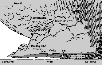 |
||||